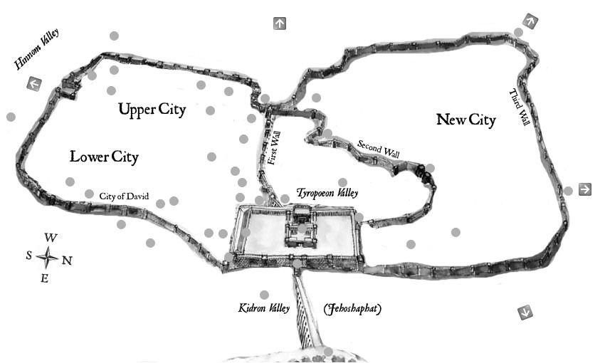
Map Illustration of Jerusalem with Five Primary Roads (See Arrows) During the First Century AD.
Highways in Ancient Israel
In ancient Israel most people traveled on foot and Israel was a difficult place to travel. The highways and roads connected travelers to the 6 parallel divisions in the topography, Israel's cities and villages, the Dead Sea, and the Negev. The Hebrews generally followed their small roads but they were not into major road construction as the Romans were. In fact the Hebrew word for road means a beaten worn out path. Road construction would have been difficult for any skillful engineer because of the topography of the land. When Jesus journeyed from Jerusalem through the land of Samaria (John 4) there were no special roads but large dirt paths with some stone. As He journeyed around Nazareth and the surrounding villages in Galilee He was following beaten dirt tracks, with little road making.
The Romans were skillful road makers who made the great highways of the Empire, so that soldiers and horses could travel on them. Most of the travelers along Roman highways were caravans, camels, horses, and donkeys.
Jerusalem's Roads
In ancient Jerusalem there were five roads leading in and out of the city (See Arrows on Map Illustration Below): The Northern Road led to Sychem, Caesarea and Damascus. The Northeast road led to the Mount of Olives and Bethany. It also intersected with the road that led to Jericho and the Dead (Salt) Sea. The Northwestern road led to Joppa and the Mediterranean Sea. The Western road led northwest to Joppa and also southwest to Bethlehem and Hebron. The Southwestern road led to the Dead (Salt) Sea.
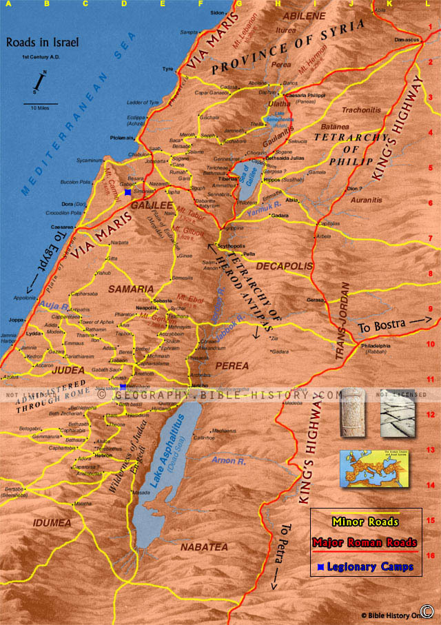
Israel's Roads
The roads in first century Israel in the time of Jesus were as follows (See Map of Israel's Highways Below):
1. The road that passed northward up the coastal plain from Gaza, (the port of the Egyptian desert), past Joppa and Caesarea round the nose of Mount Carmel up to Tyre, and Sidon. This road, at a point due west of Jerusalem, had a fork running north-eastward, climbing the foothills of Samaria and going through the valleys of Samaria (including that in which Joseph was sold to the Egyptians) to the plain of Esdraelon. Crossing that plain it climbed the Galilean hills and passed between two strange rocky peaks called the Horns of Hattin down a ravine in which dwelt thousands of pigeons that were captured in Jesus' day to be sold in the Temple for the poor to use as sacrificial offerings. Then to the Plain of Gennesaret which the road then crossed, and north through Capernaum and crossing the Jordan with Mount Hermon on it’s left, eastward to Damascus.
2. Starting in the south from Beersheba (the other port of Palestine on the Egyptian desert), a very ancient road climbed northward up the Judean hills to Hebron and through Bethlehem to Jerusalem. The Flight into Egypt from Bethlehem with the infant Jesus would probably take this route. From Jerusalem the road forked in three directions. One ran to the left down the steep ravines of the Judean hills to the coastal plain and to Joppa. It is down this road that Peter would go in the journey described in Acts. The road to the east ran even more steeply down past Bethany to the deep trench of the Jordan valley. This is the road from Jerusalem to Jericho (a descent of 3500 feet in 14 miles) that is the scene of the story of the Good Samaritan; and up its steep slopes Jesus came from Transjordania, the Jordan Valley, and Jericho, to face trial and death at Jerusalem.
3. Another road from Jerusalem ran directly northward over the hills of Judea, passing by the site of Bethel and descending into a small plain before lifting again to the hills of Samaria under the shadow of Mount Gerizim and Mount Ebal. Through Samaria it runs past the foot of Mount Gilboa across the Plain of Esdraelon, where one fork runs north-westward to Nazareth and another north-eastward by the foot of Mount Tabor and the north end of the Lake of Galilee, where it joins up with the great Way of the Sea. It will be seen that none of these roads to and from Jerusalem is a great international highway. The roads or tracks are there because Jerusalem exists; and they simply lead to and from the Holy City.
4. Moving still farther east we come upon another series of routes important in the life of Jesus. The Gospels tell us that He took the road from Galilee to Jerusalem through Samaria on at least one occasion. The fierce hostility of the Samaritans to the Jews, however, led Jews when traveling from the north to Jerusalem to turn eastward at Jezreel (the eastern gap from the Plain of Esdraelon into the Jordan Valley), and go down into that valley to join a road running southward on the western side of the river to Jericho. There the pilgrims to Jerusalem would turn west again to climb up to Jerusalem, having avoided Samaria.
5. Still farther east, on the Transjordania side of the Jordan River, roads ran in Jesus' time between the Graeco-Roman cities of Decapolis. It is highly probable that in His last journey (associated in Luke with the parables of the lost money, the lost sheep, and the prodigal son) Jesus walked upon these roads, which ran through Philadelphia, Gerasa, Gadara and up to Damascus. The road from Amman also ran southward. Jesus did not take this road; but as it ran near to the Castle of Machaerus, in which Herod Antipas imprisoned John the Baptist, John himself may have been led in chains along that route.
Map of the Roads in ancient Israel during the First Century AD.