Map of the World of the New Testament - This map reveals the "Nations" within the ancient world during the first century A.D., the time of the New Testament. The map includes the areas of Israel, Asia, Greece, and Italy.
Map of Israel in New Testament Times - Political map of Israel during New Testament times, when Pontius Pilate was procurator of Judea and Herod was Tetrarch of Galilee (Luke 3:1). The primary locations mentioned in the New Testament are listed; the roads are also listed on the map, although many roads were not always safe to travel. (Color Map)
Map of Jerusalem - This map includes the area of Jerusalem with a comparison of ancient and modern times. Jerusalem was an impressive city in ancient times, especially in the time of Herod the Great. This map shows Jerusalem in modern times with the Upper City and Lower City. (Black and White Map)
Map of Lower Galilee - This map includes some of the geographical locations within the ancient Galilee region in Israel. Lower Galilee contained many hills about 2000 feet above sea level, not as large as the northern Galilee region. It comes down like a staircase of large to smaller hills. The valley formed an easy path to the Sea of Galilee, especially to the north side of the Sea where Capernaum was located. (Color Map)
Map of Upper Galilee - This map includes some of the geographical locations within the ancient Galilee region in Israel. According to Josephus, Galilee was divided naturally into two regions divided by a very steep 2000 foot slope. (Color Map)
Map of Samaria - This map includes some of the geographical locations within the ancient Hill Country region in Israel. According to Josephus, on the north the Hill Country descends to a very steep 2000 foot slope into the Valley in the Upper Galilee region. The Hill Country was filled with mountains and was divided into four parts: Upper and Lower Galilee, the Hill Country of Samaria, and the Hill Country of Judah. The south end sloped into the Negev region. (Color Map)
Map of the Coastal Plain of Israel (Northern) - Israel and Judah both had the privilege of sharing the Coastal Plain also known as the Maritime Plain. The Northern Coastal Plain ran from the Ladder of Tyre down to Joppa as seen in the map above, although the entire Coastal plain ran south to the River of Egypt (Wadi el-Arish), the distance was about 150 miles and the width varied from 3 miles in the north to 25 miles in the south. (Color Map)
Map of the Coastal Plain of Israel (Southern) - Israel and Judah both had the privilege of sharing the Coastal Plain also known as the Maritime Plain. The Southern Coastal Plain known as the Plain of Philistia ran from the Joppa to the river below Gaza called the River of Egypt (Wadi el-Arish) as seen in the map above. (Color Map)
Map of the Northern Negev - The Negev was referred to as the "dry land," and it was south below the hills of Judah. Israel was often referred to as extending from Dan in the north to Beersheba in the south. Beersheba was in the heart of the Negev, and the Negev extends 15 mile to the north and south of Beersheba, and 40 miles from east to west. (Color Map)
Map of Israel - Judea - Judah was the southern part of the Country of Israel, when King Solomon died the kingdom was divided into two parts, "Israel" and "Judah" and the southern part of Israel became Judah. According to Scripture it went from Jaba (Geba) in the North to Beersheba in the South and Jerusalem was part of Judah. The Hebrews from Judah were referred to as Jews (Judahites) and their land was known in Greeks and Latin as "Judea." (Color Map)
Map of the Decapolis and its Cities - The Decapolis was an alliance of ten cities, originally Palestinian. All but one (Scythopolis) were on the east side of the Jordan. In New Testament times these cities were most definitely Greek in character and under the protection of Rome (Governor of Syria). (Color Map)
Map of the Edomite Territory - The Edomites were the descendants of Esau (Gen 25:25; 36:1) and lived in strong mountain fortresses. They became prosperous through agriculture, cattle, and the tribute they levied on passing caravans. (Color Map)
Map of Galilee and Northern Israel - This map includes some of the geographical locations within the ancient Galilee region in Israel. Galilee and its surrounding territory (Northern Palestine). The names that are underlined are from the Old Testament period, the others are important in New Testament times. Galilee was in the Roman province of Judea. (Color Map)
Map of Judea and Southern Israel - Judea and the surrounding territories (Southern Israel). Many of the cities in this map are known from the Old Testament period. Most were important in New Testament times. (Color Map)
Map of Samaria and Central Israel - Samaria (Central Israel) in New Testament times. The names that are underlined were important in Old Testament times. (Color Map)
Map of Jerusalem in New Testament Times - The solid lines indicates the probable site of walls and buildings that are no longer there. The dashed lines represents the present wall of the old town and the railroad tracks indicate the probable course of the main access roads. Also see below a cross section of the modern city of Jerusalem as seen from the south, with some Biblical locations. (Black and White Map)
Jerusalem Cross Section - The modern city of Jerusalem as seen from the south, with some Biblical locations. Click here to see a map of Jerusalem in the First Century AD. (Black and White Map)
Map of Asia - In New Testament times Asia referred to a Roman province located at the western part of what came to be known as Asia Minor. Asia Minor was the area between the Black Sea, Aegean Sea, and the Mediterranean Sea. The provinces seen in the above map include: Asia, Bythinia and Pontus, Galatia, Pamphylia, Lycia, Cilicia, and Commagene. (Color Map)
Map of Achaia - Achaia was a region of Greece on the north coast of the Peloponnesus. The topography of Achaia was filled with mountains and therefore was difficult to travel through and this was one of the reasons why ancient Greece was difficult to unify. The geography of Greece forced most of the population to dwell in the beautiful sea ports and thus spread their culture throughout the Mediterranean. Achaia was a Roman Province in New Testament times. Paul spent much time there and expressed his love toward the churches in Achaia, and commended them for their liberal giving. (Color Map)
Map of Adriatic Sea - Paul journeyed on this sea on his way to Rome and was met with a violent storm which caused him and his crew to be shipwrecked on the island of Malta (Acts 27:27). The Adriatic Sea or known as the Sea of Adrias in New Testament times was located between Italy on the West and Dalmatia, Macedonia and Achaia on the East, and on the South it extended into the central part of the Mediterranean Sea between the islands of Crete and Malta. Ptolemy described the Adria in his writings and Josephus mentioned that it was in this sea that he was rescued by a ship of Cyrene. (Color Map)
Map of Asia in Roman Times - Map of Asia Minor and the adjacent Mediterranean lands in Roman times. Asia was a term which in the books of the Maccabees actually means Asia Minor, which Antioch III (the Great) had to give up to the Roman province of Asia Proconsularis (formed after 133 B.C.), which embraced the regions of Mysia, Lydia, Caria, and Phrygia. (Color Map)
Map of the 7 Churches of Revelation (Asia Minor) - Position of the seven churches in Asia Minor to whom the seven epistles in Revelation 1-3 were addressed: Ephesus, Smyrna, Pergamum, Thyatira, Sardis, Philadelphia, Laodicea. (Color Map)
Boundaries and Provinces of the Roman Empire In the Time of Jesus - The Boundaries of the Roman Empire were: North: The British Channel, the Rhine, the Danube, and the Black Sea. South: The deserts of Africa, the cataracts of the Nile, & the Arabian deserts. East: The Euphrates. West: The Atlantic. (Color Map)
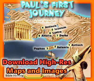
Map of Paul's Missionary Journeys - The missionary voyages of the apostle Paul from Jerusalem to Rome. This map also shows much of the Roman Empire in the time of Paul and his journeys. Roman law and order, good military roads, and the use of Koine Greek as the general language of culture throughout the area were among the factors which multiplied the rapid spread of the Gospel of Jesus Christ. (Black and White Map)