1599 Geneva Bible (GNV)
The Geneva Bible: A Cornerstone of English Protestantism A Testament to Reform The 1599 Geneva Bible... Read More

From the ancient world to the digital age, biblical maps have served not only as geographic representations but also as profound spiritual and cultural artifacts. They reflect how generations have visualized the sacred stories of the Bible—whether tracing the Israelites’ exodus, locating Eden, or plotting the journeys of the Apostle Paul. As much theological as they are topographical, these maps tell the story of how sacred texts and physical space have intertwined throughout history.
One particularly significant biblical route is the journey from Babylon to Jerusalem, a path emblematic of exile, return, and restoration. This route has captivated scholars and believers alike, inspiring cartographic interpretations that connect geography to prophecy.
In ancient Israel and early Christianity, geography was experienced more through narrative than visual representation. Biblical texts such as Genesis, Exodus, and Kings overflow with place names—Eden, Canaan, Sinai, Babylon, and Jerusalem—but there is little evidence of maps in the modern sense.
Still, understanding how far it is from Babylon to Jerusalem was more than a question of distance—it was a spiritual journey. The exile to Babylon and the eventual return under Persian rule (as told in Ezra and Nehemiah) were defining moments. Theologically and cartographically, this journey from Babylon to Jerusalem became symbolic of redemption and divine promise.
One of the earliest known attempts to depict the Holy Land is the Madaba Map, a 6th-century mosaic floor located in Jordan. Crafted for a Byzantine church, the map includes detailed renderings of Jerusalem, Bethlehem, and other significant biblical locations. Though not to scale, it demonstrates a growing desire to root sacred history in physical geography.
Later Christian scholars began to address literal distances as well, pondering how many miles from Babylon to Jerusalem and mapping the routes taken by Old Testament figures. Such maps served both pilgrims and theologians, enabling spiritual reflection through spatial awareness.
In medieval Europe, maps such as the Hereford Mappa Mundi presented the world as a theological diagram. Jerusalem was placed at the center of the world, symbolizing spiritual centrality, while Babylon was also prominently featured due to its role as the "city of exile."
For many, the idea of moving from Babylon to Jerusalem wasn't just historical—it was a metaphor for moving from sin to salvation. Medieval scholars might not have measured how far is Jerusalem from Babylon in exact terms, but their maps depicted the profound symbolic distance between the two cities.
With the advent of the printing press in the 15th century, biblical maps began to take on more realistic proportions. Cartographers like Abraham Ortelius and Sebastian Münster attempted to reconcile biblical geography with classical and modern geographic knowledge.
In this period, maps began to address questions like "how far is Babylon from Jerusalem" with growing accuracy. The standard overland distance between the two cities is often calculated around 500–600 miles, though the precise route varies depending on terrain and historical travel paths.
This increased precision reflected a shift from symbolic to literal geography, driven by theological study and the expansion of global exploration.
The 18th and 19th centuries brought empirical methodologies to biblical cartography. Explorers and archaeologists in the Middle East—especially in Palestine and Mesopotamia—sought to match biblical sites with historical and archaeological evidence.
Maps from this era carefully noted distances like those between Jerusalem and Babylon, reflecting not just curiosity but an effort to verify the historicity of Scripture. Interest in how far is it from Babylon to Jerusalem surged among biblical scholars, who viewed such data as key to understanding prophetic timelines and historical movements.
This was also a period when colonial powers mapped the biblical world through a political lens, often blending faith, empire, and geography in complex ways.
In the 20th and 21st centuries, biblical mapping reached new heights of sophistication. Institutions like the Palestine Exploration Fund and resources such as the Zondervan Bible Atlas and Oxford Bible Atlas provide high-resolution, archaeologically grounded maps.
Digital platforms now let users explore routes such as the journey from Babylon to Jerusalem interactively, complete with archaeological annotations, distance calculators, and historical overlays. Whether you're asking how far is Babylon from Jerusalem or seeking visual reconstructions of ancient Jerusalem, digital cartography offers precise, customizable insights.
For an in-depth look at this iconic route and its historical significance, you can explore this excellent article:
👉 Babylon to Jerusalem: A Journey Through Biblical History
This resource also answers common geographic questions such as:
Biblical maps are far more than tools of navigation—they are acts of interpretation, devotion, and identity. From early Christian mosaics to modern GPS-enabled platforms, these maps allow us to walk through Scripture with spatial awareness. The enduring fascination with routes like that from Babylon to Jerusalem shows how deeply geography and theology are intertwined.
As technology continues to evolve, so too will our maps of sacred space—but the quest to understand how distance, place, and divine purpose intersect remains timeless.
The Geneva Bible: A Cornerstone of English Protestantism A Testament to Reform The 1599 Geneva Bible... Read More
The 21st Century King James Version (KJ21): A Modern Approach to a Classic Text A Balancing Act The ... Read More
The American Standard Version (ASV): A Cornerstone of Modern English Bibles A Product of Scholarly R... Read More
The Amplified Bible (AMP): A Rich and Comprehensive Translation The Amplified Bible (AMP) stands out... Read More
The Amplified Bible, Classic Edition (AMPC): A Timeless Treasure The Amplified Bible, Classic Editio... Read More
The Authorized (King James) Version (AKJV): A Timeless Classic The Authorized King James Version (AK... Read More
The BRG Bible: A Colorful Approach to Scripture A Unique Visual Experience The BRG Bible, an acronym... Read More
The Christian Standard Bible (CSB): A Balance of Accuracy and Readability The Christian Standard Bib... Read More
The Common English Bible (CEB): A Translation for Everyone The Common English Bible (CEB) is a conte... Read More
The Complete Jewish Bible (CJB): A Jewish Perspective on Scripture The Complete Jewish Bible (CJB) i... Read More
The Contemporary English Version (CEV): A Bible for Everyone The Contemporary English Version (CEV),... Read More
The Darby Translation: A Literal Approach to Scripture The Darby Translation, often referred to as t... Read More
The Disciples' Literal New Testament (DLNT): A Window into the Apostolic Mind The Disciples’ Literal... Read More
The Douay-Rheims 1899 American Edition (DRA): A Cornerstone of English Catholicism The Douay-Rheims ... Read More
The Easy-to-Read Version (ERV): A Bible for Everyone The Easy-to-Read Version (ERV) is a modern Engl... Read More
The English Standard Version (ESV): A Modern Classic The English Standard Version (ESV) is a contemp... Read More
The English Standard Version Anglicised (ESVUK): A British Accent on Scripture The English Standard ... Read More
The Evangelical Heritage Version (EHV): A Lutheran Perspective The Evangelical Heritage Version (EHV... Read More
The Expanded Bible (EXB): A Study Bible in Text Form The Expanded Bible (EXB) is a unique translatio... Read More
GOD'S WORD Translation (GW): A Modern Approach to Scripture The GOD'S WORD Translation (GW) is a con... Read More
The Good News Translation (GNT): A Bible for Everyone The Good News Translation (GNT), formerly know... Read More
The Holman Christian Standard Bible (HCSB): A Balance of Accuracy and Readability The Holman Christi... Read More
The International Children's Bible (ICB): A Gateway to Faith The International Children's Bible (ICB... Read More
The International Standard Version (ISV): A Modern Approach to Scripture The International Standard ... Read More
The J.B. Phillips New Testament: A Modern Classic The J.B. Phillips New Testament, often referred to... Read More
The Jubilee Bible 2000 (JUB): A Unique Approach to Translation The Jubilee Bible 2000 (JUB) is a dis... Read More
The King James Version (KJV): A Timeless Classic The King James Version (KJV), also known as the Aut... Read More
The Lexham English Bible (LEB): A Transparent Approach to Translation The Lexham English Bible (LEB)... Read More
The Living Bible (TLB): A Paraphrase for Modern Readers The Living Bible (TLB) is a unique rendering... Read More
The Modern English Version (MEV): A Contemporary Take on Tradition The Modern English Version (MEV) ... Read More
The Mounce Reverse Interlinear New Testament: A Bridge to the Greek The Mounce Reverse Interlinear N... Read More
The Names of God Bible (NOG): A Unique Approach to Scripture The Names of God Bible (NOG) is a disti... Read More
The New American Bible, Revised Edition (NABRE): A Cornerstone of English Catholicism The New Americ... Read More
The New American Standard Bible (NASB): A Cornerstone of Literal Translations The New American Stand... Read More
The New American Standard Bible 1995 (NASB1995): A Refined Classic The New American Standard Bible 1... Read More
The New Catholic Bible (NCB): A Modern Translation for a New Generation The New Catholic Bible (NCB)... Read More
The New Century Version (NCV): A Bible for Everyone The New Century Version (NCV) is an English tran... Read More
The New English Translation (NET): A Transparent Approach to Scripture The New English Translation (... Read More
The New International Reader's Version (NIRV): A Bible for Everyone The New International Reader's V... Read More
The New International Version - UK (NIVUK): A British Accent on Scripture The New International Vers... Read More
The New International Version (NIV): A Modern Classic The New International Version (NIV) is one of ... Read More
The New King James Version (NKJV): A Modern Update of a Classic The New King James Version (NKJV) is... Read More
The New Life Version (NLV): A Bible for All The New Life Version (NLV) is a unique English translati... Read More
The New Living Translation (NLT): A Modern Approach to Scripture The New Living Translation (NLT) is... Read More
The New Matthew Bible (NMB): A Reformation Revival The New Matthew Bible (NMB) is a unique project t... Read More
The New Revised Standard Version (NRSV): A Modern Classic The New Revised Standard Version (NRSV) is... Read More
The New Revised Standard Version Catholic Edition (NRSVCE): A Cornerstone of Modern Catholicism The ... Read More
The New Revised Standard Version, Anglicised (NRSVA): A British Accent on Scripture The New Revised ... Read More
The New Revised Standard Version, Anglicised Catholic Edition (NRSVACE): A Bridge Between Tradition ... Read More
The New Testament for Everyone (NTE): A Fresh Perspective The New Testament for Everyone (NTE) is a ... Read More
The Orthodox Jewish Bible (OJB): A Unique Perspective The Orthodox Jewish Bible (OJB) is a distincti... Read More
The Revised Geneva Translation (RGT): A Return to the Roots The Revised Geneva Translation (RGT) is ... Read More
The Revised Standard Version (RSV): A Cornerstone of Modern English Bibles The Revised Standard Vers... Read More
The Revised Standard Version Catholic Edition (RSVCE): A Cornerstone of English Catholicism The Revi... Read More
The Message (MSG): A Contemporary Paraphrase The Message, often abbreviated as MSG, is a contemporar... Read More
The Voice: A Fresh Perspective on Scripture The Voice is a contemporary English translation of the B... Read More
The Tree of Life Version (TLV): A Messianic Jewish Perspective The Tree of Life Version (TLV) is a u... Read More
The World English Bible (WEB): A Modern Update on a Classic The World English Bible (WEB) is a conte... Read More
The Worldwide English (WE) New Testament: A Modern Take on a Classic The Worldwide English (WE) New ... Read More
The Wycliffe Bible: A Cornerstone of English Scripture A Revolutionary Translation The Wycliffe Bibl... Read More
Young's Literal Translation (YLT): A Literal Approach to Scripture Young's Literal Translation (YLT)... Read More
For enthusiastic readers, managing a collection of books can become challenging. An expanding "to be... Read More
Deuteronomy 18 - "And if you say in your heart, 'How shall we know the word which the LORD has not ... Read More
John 14:26 - "But the Counselor, the Holy Spirit, whom the Father will send in my name, he will teac... Read More
(Enlarge) (PDF for Print) Map of the Origin of Nations and Races that were dispersed by God in Gene... Read More
The Journeys of Abraham (Enlarge) (PDF for Print) - Map of Abraham's Journey with Trade Routes Map ... Read More
(Enlarge) (PDF for Print) Map of the Route of the Hebrews from Egypt This map shows the Exodus of t... Read More
Mark 6:52 - For they considered not the miracle of the loaves: for their heart was hardened. God did... Read More
also see:The Encampment of the Children of IsraelThe Children of Israel on the March THE OUTER COURT... Read More
2 Chronicles 36:23 - Thus saith Cyrus king of Persia, All the kingdoms of the earth hath the LORD Go... Read More
All Bible Maps - Complete and growing list of Bible History Online Bible Maps. Old Testament Maps T... Read More
The Bible portrays marriage as a lifelong bond built on love, faith, and commitment, reflecting God'... Read More
Ancient Manners and Customs, Daily Life, Cultures, Bible Lands NINEVEH was the famous capital of an... Read More
Distances From Jerusalem to: Bethany - 2 milesBethlehem - 6 milesBethphage - 1 mileCaesarea - 57 m... Read More
Dagon was the god of the Philistines. This image shows that the idol was represented in the combina... Read More
Map of Israel in the Time of Jesus (Enlarge) (PDF for Print) Map of First Century Israel with Roads... Read More
The Table of Shewbread (Ex 25:23-30) It was also called the Table of the Presence. Now we will pas... Read More
see also:The PriestThe Consecration of the PriestsThe Priestly Garments The Priestly Garments 'The ... Read More
Introduction to the Book of Daniel in the Bible Daniel 6:15-16 - Then these men assembled unto the k... Read More
The Golden Lampstand was hammered from one piece of gold. Exod 25:31-40 "You shall also make a lam... Read More
The Golden Altar of Incense (Ex 30:1-10) The Golden Altar of Incense was 2 cubits tall.It was 1 cub... Read More
Ancient Tax Collector Illustration of a Tax Collector collecting taxes Tax collectors were very des... Read More
also see: Blood Atonement and The Priests The Five Levitical Offerings The Sacrifices The sacrificia... Read More
Genesis 10:32 - These are the families of the sons of Noah, after their generations, in their nation... Read More
Illustration of Jesus Reading from the Book of Isaiah This sketch contains a colored illustration o... Read More
"But the angel said unto him, Fear not, Zacharias: for thy prayer is heard; and thy wife Elisabeth s... Read More
also see: The Encampment of the Children of IsraelThe Children of Israel on the March The brazen a... Read More
In a rapidly evolving world shaped by both timeless values and groundbreaking technology, individual... Read More
Rome, the Eternal City, has stood as a symbol of history, culture, and religion for over two millenn... Read More
Many teachers assign pieces titled “an essay about god in my life.” The title invites calm thought a... Read More
Exploring identity has become part of the digital life. Social media, streaming, and gaming give you... Read More
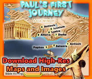
Unearth the rich tapestry of biblical history with our extensive collection of over 1000 meticulously curated Bible Maps and Images. Enhance your understanding of scripture and embark on a journey through the lands and events of the Bible.
Start Your Journey Today!