"When the Lord has finished all His work...he will punish the arrogant boasting of the king of Assyria and his haughty pride." Isaiah 10:12
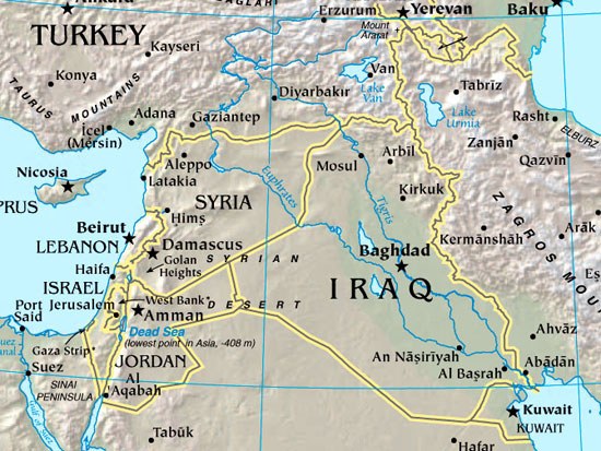
Map of Modern Iraq
Geography of Modern Iraq
LOCATION & GEOGRAPHY: Iraq is located in the Middle East. It is bound by Iran to the east, Turkey to the north, Syria to the northwest, Jordan to the west, Saudi Arabia to the southwest and south as well as Kuwait and the Persian Gulf to the southeast. The country can be divided into four main topographical regions.
(1.) The northeastern highlands which include the Zagros Mountains.
(2.) The upland between the Tigris and Euphrates Rivers, which is mostly desert.
(3.) A marshland region just above the convergence of the two rivers and
(4.) the extensive barren, rock and sand desert region in the south and west which constitute part of the Great Arabian and Syrian Deserts.
Around 38% of the total land area is desert while the principal rivers are the Tigris and Euphrates.
Land Use; forested 0.5%, pastures 9%, agricultural-cultivated 12.5%, other 78% (1993).
CLIMATE: Iraq has an arid climate with hot dry summers from May to October and cold winters from December to March with most of the rainfall occurring between December to March. In Baghdad the average annual precipitation is 140 mm (6 inches) whilst in the northeast where it is highest, it varies from 400 to 600 mm (16 to 23 inches) annually. Elsewhere, rainfall is low and unreliable. The prevailing winds are the Sharqi or Sirocco, a southeasterly dry dust laden wind and the Shamal, a northwesterly dry cool wind. Average temperature ranges in Baghdad are from 4 to 16 degrees Celsius (39 to 61 degrees Fahrenheit) in January to 24 to 50 degrees Celsius (75 to 122 degrees Fahrenheit) in July or August.